
If you’ve been keeping up with the development in our area, you’re likely aware of the repeated instances of flooding we’ve experienced. Our primary concern is that further development, especially if it involves the destruction of the vibrant waterlogged area behind our houses, will exacerbate these issues. Currently, this area serves as a vital soakaway for excess water and a sanctuary for wildlife. However, if it’s compromised, the risk of flooding on our roads and even in our homes becomes a serious concern.
We have reservations about the accuracy of their figures and whether they provide a complete representation of the situation, especially considering the unpredictable nature of climate change.
Hence the document below.
Download a copy on our documents page.
PLANNING APPLICATION LA05/2022/0033/F
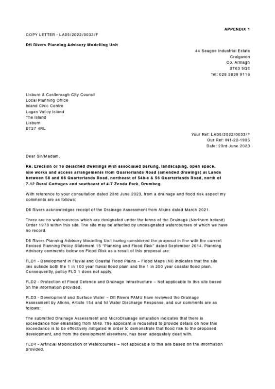
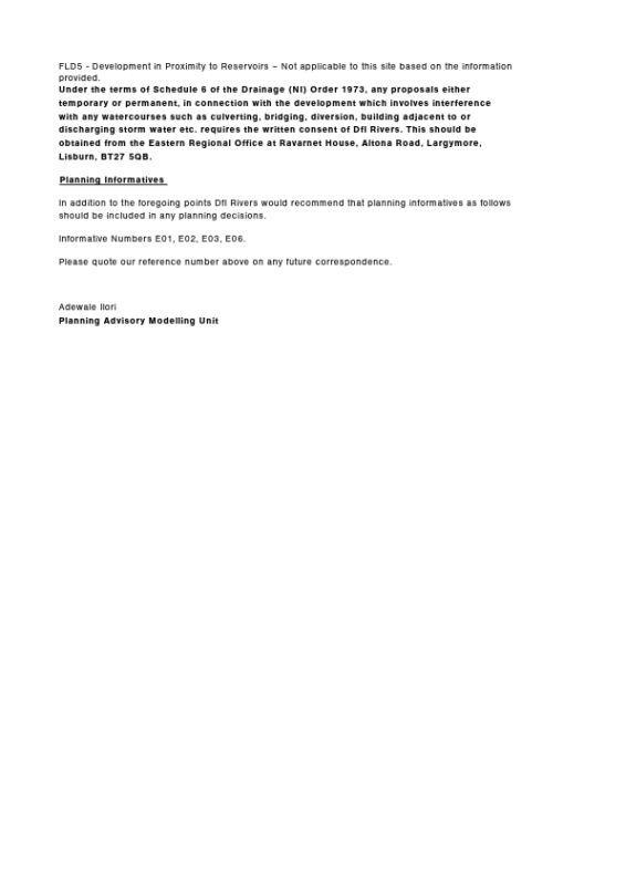
We attach at Appendix 1 a copy of Dfl Rivers Planning Advisory Modelling Unit River Agency’s response to a request for comment on the flood and risk aspects of the above development.
APPENDIX 1
As a group of concerned residents, we have sought specialist advice on flooding risk from a review of the Atkins Drainage Assessment Report August 2023
From this review the following facts have been established:
STORM DRAINAGE DESIGN
- On page 6 of Appendix G of the Atkins Report a summary of the System Volume is provided. S1 has the lowest Ceiling Level of the 10 listed at 25.226m AOD. This means that when the pipes and manhole chambers in the whole system are filled with storm water to a level of 25.226 AOD, it will leak out of S1 as it is the lowest escape point in the system. This would result in the surcharged water escaping from S1 onto the Quarterlands Road. Flooding on the Quarterlands Road is already documented Appendix 2
- From the Table the Calculated Water Vol Storage (Chambers and Pipes) is 169 m3. Achievable Attenuation total water volume is 150m3.(difference 19m3). Difference divided by Calculated Volume 19/169 = 11%. The System therefore can store 89% of the calculated water volume.
- CL 25.672 at manhole on Quarterlands Road. S1 CL 25.226, which is the lowest level of CL for the Site, therefore it would flood first on to the Quarterlands Road. The next Lowest CL is S5 at 25.404 at Site10.
- The Hydro-Brake vortex flow control is sited in the Wayleave. It is 2.4 m wide and 3.5m deep. It fills to 2.5m when the water starts to back up. The Map in Appendix G shows that when the Hydro-Brake is surcharged then the first escape route is to 2 road gulleys and then to S1 as the water level rises also escaping along the other gulleys towards Quarterlands Road. The water escaping from the first 2 gulleys will escape into sites 3,4,5 because of the site’s gradient. It is important to note that there is a 900mm pipe entering the Hydro-Brake with a vortex flow control and a 300mm pipe leaving it. Should the Hydro-Brake become obstructed by debris this could cause it to malfunction. Maintenance of the total system, not only the Hydro-Brake but also the Road Gulleys of which there are 22 on the site, will be important to ensure they stay clear of any obstructions. This we understand will be by NIW when adopted.
- Should the Hydro-Brake malfunction the storm water backs up in the pipes and the chamber system.
Once the pipes and manhole chambers in the whole system are filled with storm water to a level of 25.226m AOD it will leak out from S1 as it is the lowest escape point within the system. From our calculations it will take 26 minutes to overwhelm the storm drainage from the point at which the Hydro-Brake malfunctions.
SURFACE WATER RUN-OFF FROM THE SITE
From the Table at Appendix F of the Atkins Report the proposed development site Pre-Development has a Permeable area of 100% and an Impermeable area of 0%. Post Development the Permeable area is reduced to 50.50% and the Impermeable Area increased to 49.50%
APPENDIX 3
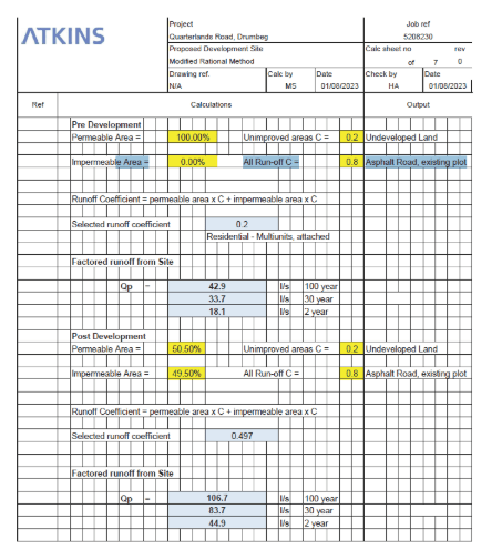
However, when comparing the pre- and post-development periods the Factored run-off for the site has more than doubled for the 100 years, 30 or 2 year risk periods respectively i.e.: 42.9L/sec,33.7 L/sec; 18.1L/sec Vs 106.7L/sec; and 83.7L/ sec,44.9L/Sec. This is because of the removal of large sections of the Soakaway presently provided by the permeable surface area of the 2 fields.
However, It is of interest the Atkins calculations for the run-off for the site if the surface area was 100% impermeable; for 100m years was 214 L/s, for 30 yrs 168.5l/s and for 2 yrs 90.3l/s. Their present assessments have been for a 49.5% impermeable surface. If this surface area increases to say 60% or greater the run-off from the site will further increase which will discharge from the site via S1 on to Quarterlands Road when the Hydro Brake malfunctions or if it is surcharged and the water backs up.
There are obvious risks of flooding in the surrounding area and in neighbouring homes. The risk is apparent for homes in the Quarterlands Lane area, evident from the map at Appendix 2.
APPENDIX 2
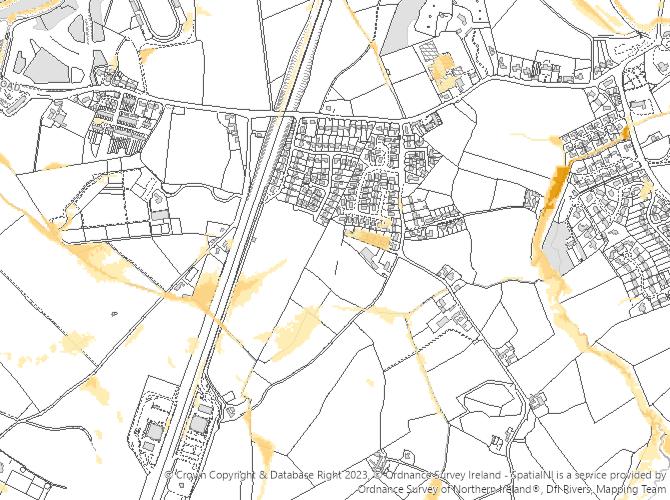
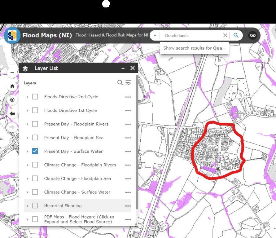
RIVER AGENCY FLOOD MAP – QUARTERLANDS
Find these maps yourself here
We are obviously concerned as we consider our homes are at future risk should this application secure planning permission. We would be grateful to have access to the calculations upon which the Planning Advisory Modelling Unit based its conclusions and its review of the data provided by the planning applicant in respect of this planning application.
Please regard these requests as made under the Freedom of Information legislation.
Yours sincerely
Quarterlands Group